Connecticut Public Radio-This new map shows which CT communities are hardest hit by environmental hazards

Connecticut Public Radio | By Michayla Savitt

Published July 26, 2023 at 11:29 AM EDT
Children playing Lighthouse Point Park New Haven
Ryan Caron King/Connecticut Public
FILE, 2022: Kids and their parents cool off in a splash pad at Lighthouse Point Park in New Haven during a stretch of hot weather in Connecticut.

A new interactive map from the Connecticut Institute for Resilience and Climate Adaptation (CIRCA) shows areas in the state that are vulnerable to environmental hazards.

Researchers made the map in English and Spanish as a way to show where pollution is coming from – and how it’s impacting nearby people. The launch coincides with a newly-strengthened state environmental justice law, as advocates look for new ways to raise the profile of historically marginalized communities overburdened by pollution.

The map features indicators like health sensitivities, a community’s wealth, and its proximity to environmental hazards such as landfills, said Yaprak Onat, co-project manager and associate director of research at CIRCA.

“What this tool does is give a first glance screening of who’s taking the toll more – who is disproportionately affected by possible pollution burden,” Onat said.

CIRCA made the tool as part of statewide plans to mitigate climate change by identifying communities most at risk. Several other states have implemented similar environmental justice screening tools.

CT Public Radio – Deluge of rain prompts CT communities to assess climate resiliency

https://www.ctpublic.org/news/2023-07-18/deluge-of-rain-prompts-ct-communities-to-assess-climate-resiliency

Ferry Glastonbury Flood
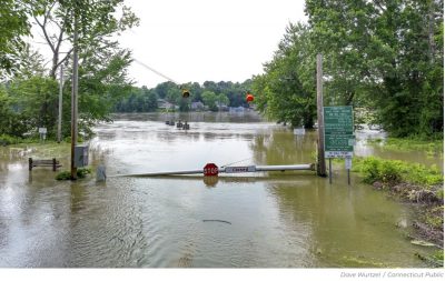
The CT DOT ferry dock in Glastonbury, CT after flooding from the Connecticut River on July 12, 2023.
Local experts are brainstorming with Connecticut municipalities about possible resilience measures against climate change’s impact on future storms, as more rain is expected through this weekend.

Rain showers have slammed the state and the Northeast for over a week, flooding rivers, farms, roads, and buildings. Several more inches of rain hit Vermont, prompting emergency federal aid and causing additional flooding.

Greg Carbin, chief of forecast operations at the NOAA’s Weather Prediction Center, said climate change has locked in this period of heavy precipitation, since warmer oceans lead more water vapor to end up in the atmosphere. And it’s happening more often.

“We’ve had a number of repeat episodes with rainfall extremes that in the past you would expect to occur maybe every few decades, maybe once every hundred years,” Carbin said. “But they seem to be on the increase, which we would expect with a warmer climate.”

David Murphy, the director of resilience planning at the Connecticut Institute for Resilience and Climate Adaptation (CIRCA), has been working directly with towns on solutions for mitigating flooding. Those range from increasing pipe capacity, to creating sidewalk rain gardens. But it’s not an easy or quick process.

“Maybe they have funds to replace two bridges and not five. And so the next time there’s a flood, they see the results of that: two of them didn’t flood as badly and three of them may have washed out,” Murphy said. “So they do make progress.”

Murphy said while Connecticut towns have overall done a good job strategically rebuilding after past floods, it always takes more time, and funding, that towns don’t always have.

Some of the hottest days in Earth’s record happened the first week of July. Climate change is already causing weather events, from heat waves to drought, to be more frequent and intense.

Even more, peak hurricane season is not far off, and Murphy is worried about towns being able to recover before a possible big storm arrives.

“It’s about a year for the average washout of a major road to get completely restored, it just takes time,” Murphy said. “And so if something hits us in August, September, there may be areas that just have not yet had a chance to rebuild.”

State officials are also working to face the issue head-on: in June, Gov. Ned Lamont announced state funding that named Bristol, Hartford, Manchester, and Norwalk as recipients for flood resilience planning. Several other projects were also funded in the nearly $9 million awarded to 21 inaugural grant winners.

Public Comment Period is Live

The Public Comment period for the EJ Screening Tool is between July 17 and July 31. To help us better understand what communities need and your opinion of the accessibility of the screening tool, voice your concerns, questions and comments here.

To access the screening tool in English, click here.


El período de comentarios públicos para la herramienta de detección EJ es entre el 17 y el 31 de julio. Para ayudarnos a entender mejor lo que las comunidades necesitan y su opinión sobre la accesibilidad de la herramienta de detección, exprese sus inquietudes, preguntas y comentarios aquí.

Para acceder a la herramienta de selección en inglés, haga clic aquí 

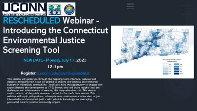
Webinar – Introducing the Connecticut Environmental Justice Screening Tool

Webinar is RESCHEDULED to Monday, July 17, 2023, 12-1 pm

This session will guide you through the mapping tool’s interface, features, and datasets, revealing how it can be utilized to analyze and address environmental burdens in vulnerable communities. You’ll also have the opportunity to engage with experts behind the development of CT EJScreen, who will share insights into the challenges and achievements of creating this comprehensive tool. This session marks the start of the public comment period for the tool’s beta version. This webinar will equip policymakers, urban planners, environmental advocates, or just interested in environmental justice with valuable knowledge on leveraging geospatial data for positive community impact.

CT EJ Mapping Tool Presented at GIS Day

On 11/18/22, our members from our team, Dr. Yaprak Onat and Caterina Massidda presented at Connecticut’s GIS Day. Here, Massidda presented on the methodology that was used to develop the statewide Environmental Justice Tool. Onat, along with Meg McGaffin presented on mapping the climate change vulnerability and expanded on the Climate Change Vulnerability index which was completed early in 2022.

To learn more about Connecticut GIS Day and the presentations, click here. 

Mapping Tool Advisory Committee (MTAC) Members Announced

Earlier in the fall CIRCA announced the application window for the Mapping Tool Advisory Committee (MTAC), a group of community-based organizations and individuals with lived experience who will receive grant funding to participate in the review of the Statewide Environmental Justice Mapping Tool currently under development by CIRCA and DEEP. The final MTAC recipients have now been selected, including community-based organizations and individuals with a wide range of expertise and lived experience. Further information on the MTAC’s role and its newly selected members can be found here.

Reminder: Mapping Tool Advisory Committee Applications Due 10/12

Individuals and community-based organizations active in environmental justice work or related work in Connecticut are encouraged to apply to the Environmental Justice Mapping Tool Advisory Committee (MTAC). Applications close October 12th, 2022.


See the flyer below for an overview of the grant and find application links here.

Loader Loading...
EAD Logo Taking too long?

Reload Reload document
| Open Open in new tab

Download